
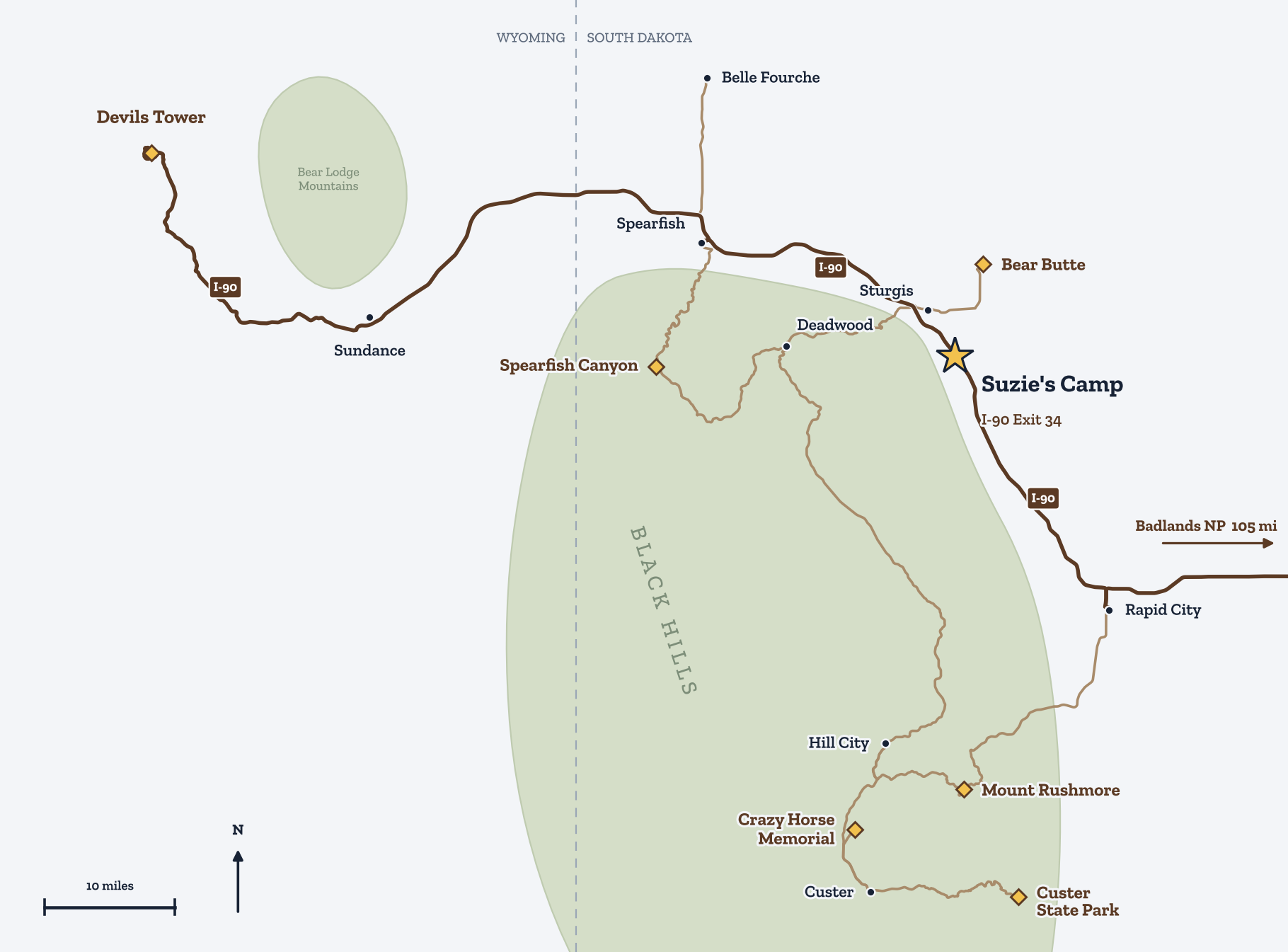
Mount Rushmore is 48 miles from Suzies Camp at I-90 Exit 34 near Sturgis, South Dakota, about 1 hr 15 min by car. Deadwood is 18 miles away (about 25 minutes), Rapid City 26 miles (about 35 minutes) and Devils Tower 86 miles (about 1 hr 55 min).
We measured every drive from camp with OpenStreetMap routing, then added about 15% so the times match real traffic instead of a best case. Mountain roads in the southern Hills are slower than the miles suggest, and summer traffic around Keystone and Mount Rushmore adds more.
Drive times from Suzies Camp
| Place | Road miles | Drive | Best season | What it is |
|---|---|---|---|---|
| Black Hills National Cemetery | 1 mi | about 5 min | Year-round | At the Exit 34 interchange. Free; open daily. Busy on Memorial Day. |
| Sturgis Motorcycle Museum | 5 mi | about 10 min | Year-round | Motorcycle museum and Hall of Fame on Main Street. |
| Downtown Sturgis (Main Street) | 6 mi | about 10 min | Year-round | Shops, cafes and the rally's main stage street. Quiet outside August. |
| Bear Butte State Park | 12 mi | about 25 min | Year-round | Sacred mountain to many Plains tribes. 1.85-mi summit trail; no pets on the summit trail; leave prayer cloths untouched and unphotographed. North end of the 111-mi Centennial Trail. |
| Deadwood | 18 mi | about 25 min | Year-round | Gold-rush town: Main Street history, Mount Moriah Cemetery, and the north end of the Mickelson Trail. |
| Lead | 21 mi | about 30 min | Year-round | Homestake mine history and the Sanford Lab Homestake Visitor Center. |
| Spearfish | 24 mi | about 35 min | Year-round | College town at the mouth of Spearfish Canyon. |
| Rapid City | 26 mi | about 35 min | Year-round | Groceries, dining, shopping, the airport (RAP) and Reptile Gardens/Bear Country on the way south. |
| Terry Peak Ski Area | 28 mi | about 55 min | Winter | Skiing and snowboarding in the northern Hills. |
| Spearfish Canyon (Savoy / Spearfish Canyon Lodge) | 35 mi | about 55 min | Spring, summer, fall | US-14A through limestone cliffs; Bridal Veil, Roughlock and Spearfish falls. Peak color late Sept to early Oct. |
| Keystone | 46 mi | about 1 hr 5 min | Summer | Gateway town below Mount Rushmore. |
| Mount Rushmore National Memorial | 48 mi | about 1 hr 15 min | Year-round | The national memorial. Leashed pets only in parking areas, the Blackberry Trail and the pet exercise area. |
| Hill City | 53 mi | about 1 hr 15 min | Summer, fall | Galleries, wineries and the 1880 Train. |
| Custer State Park Visitor Center | 56 mi | about 1 hr 25 min | Year-round | Bison herds, the Wildlife Loop, Needles Highway and Iron Mountain Road. Buffalo Roundup is in late September. |
| Sylvan Lake | 62 mi | about 1 hr 35 min | Summer, fall | Granite-ringed lake at the start of Needles Highway; trailhead for Black Elk Peak. |
| Crazy Horse Memorial | 64 mi | about 1 hr 45 min | Year-round | The mountain carving in progress and the Indian Museum of North America. |
| Wall Drug | 77 mi | about 1 hr 35 min | Year-round | The famous roadside stop on the way to the Badlands. |
| Badlands National Park (Pinnacles Entrance) | 84 mi | about 1 hr 50 min | Spring, summer, fall | Straight down I-90. Badlands Loop Road (SD-240) between the Pinnacles and Interior entrances. |
| Wind Cave National Park Visitor Center | 86 mi | about 2 hr 10 min | Year-round | Cave tours and prairie wildlife. |
| Devils Tower National Monument | 86 mi | about 1 hr 55 min | Spring, summer, fall | America's first national monument, in Wyoming. 1.3-mi Tower Trail loop. |
| Gillette, WY | 117 mi | about 2 hr 20 min | Year-round | Next big town west on I-90 (for the 'tonight' traveler band). |
Which trips pair well?
- Deadwood, Lead and Spearfish Canyon. Deadwood (18 miles) and Lead (21 miles) sit side by side; US-14A then runs down Spearfish Canyon to Spearfish (24 miles) and back to I-90. A half day to a full day.
- Mount Rushmore, Keystone and Custer State Park. The big southern day: Rapid City, Keystone (46 miles), Mount Rushmore (48 miles), Iron Mountain Road and the Wildlife Loop.
- Crazy Horse, Hill City and Sylvan Lake. Crazy Horse Memorial (64 miles), Hill City (53 miles) and Sylvan Lake (62 miles) are close together in the central Hills.
- The Badlands and Wall Drug. Straight east on I-90: Wall Drug (77 miles), then the Badlands Pinnacles entrance (84 miles).
- Devils Tower. 86 miles west into Wyoming. Come home through Spearfish Canyon if there’s daylight left.
Which roads should I know about?
Needles Highway (SD-87, 14 miles) and Iron Mountain Road (US-16A, 17 miles, with its “pigtail” bridges) are two of the best drives in the Black Hills, and both squeeze through one-lane rock tunnels. Our advice: leave the RV or trailer at camp and take the tow vehicle.
| Tunnel | Road | Width | Height |
|---|---|---|---|
| Needles Eye | Needles Highway | 8 ft 0 in | 9 ft 9 in |
| Iron Creek | Needles Highway | 8 ft 9 in | 10 ft 10 in |
| Scovel Johnson | Iron Mountain Road | 10 ft 9 in | 11 ft 0 in |
| C.C. Gideon | Iron Mountain Road | 11 ft 6 in | 10 ft 9 in |
| Doane Robinson | Iron Mountain Road | 12 ft 0 in | 11 ft 4 in |
What do the parks cost?
- Custer State Park: a park entrance license, $25 per vehicle for 1–7 days.
- Mount Rushmore: no entrance fee, but parking is $10 per vehicle (good for a year). Federal passes don’t cover parking.
- Badlands National Park: $30 per vehicle for 7 days ($25 motorcycle).
- Devils Tower: $25 per vehicle ($20 motorcycle), cards only.
- An America the Beautiful pass covers the Badlands and Devils Tower entrance fees.
Where can I get gas and groceries?
Sturgis, about 10 minutes from camp, has groceries and fuel. Rapid City has the big stores and the airport. On a southern Hills day, fill up in Rapid City or Keystone before heading into Custer State Park.
Stay at Suzies Camp
Suzies Camp is a quiet, owner-run campground at I-90 Exit 34 near Sturgis, South Dakota: 18 dry cabins, 60 RV sites and 15 tent sites. See drive times to the whole Black Hills.